
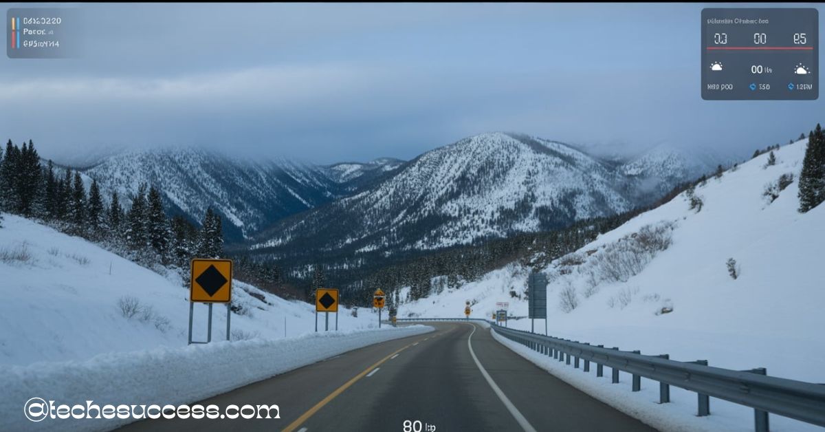
The Monida Pass camera provides real-time road and weather updates along I-15 at the Montana-Idaho border. It helps travelers monitor snow, traffic, and visibility conditions before hitting the road. Stay safe and informed with the live Monida Pass camera feed.
“Stay tuned with us as we dive deep into everything you need to know about the Monida Pass camera—from live road updates to real-time weather conditions and smart travel tips.”
What is the Monida Pass and Why It Matters for Travelers
The Monida Pass is a high mountain pass situated at an elevation of around 6,820 feet (2,080 meters) above sea level. It lies on the boundary between Montana and Idaho and forms a crucial segment of Interstate 15 (I-15). Named after the two states it connects (MONtana and IDAho), this corridor is not just geographically significant—it’s a key transportation route for travelers and freight.
For motorists, Monida Pass is both a scenic route and a potential hazard. While the natural beauty of the surrounding terrain draws tourists, the high elevation often results in adverse weather, especially in the winter months. Snow, ice, and strong winds are frequent, making it a challenging stretch of highway during certain times of the year.
Because of its strategic importance, Monida Pass is heavily monitored by state transportation departments. The Monida Pass camera and Montana live Cameras Map tools are among the technologies used to ensure that drivers can stay informed in real-time about what’s happening on the road. Whether you’re planning a road trip, driving a delivery truck, or simply commuting between states, knowing the conditions on Monida Pass is essential.
Monida Pass Camera: A Reliable Tool for Road Monitoring
When it comes to monitoring remote or weather-prone roadways, live cameras are one of the most effective tools available. The Monida Pass camera live stream provides a continuous flow of visuals, allowing travelers to see exactly what the current road and weather conditions look like.
Installed and maintained by state departments such as the Montana Department of Transportation (MDT) and Idaho Transportation Department (ITD), these cameras operate year-round. They’re strategically placed to cover the most critical parts of the pass—areas prone to snow accumulation, black ice, and low visibility.
The camera feed updates frequently, offering snapshots every few minutes or a live stream depending on the system. These visuals not only benefit drivers but also aid in emergency response, snowplow deployment, and traffic management.
With one glance at the Monida Pass camera live, you can:
- Assess whether the road is clear or snow-covered
- Check visibility during foggy or snowy days
- Plan whether it’s safe to proceed or delay your journey
The camera is one of the most trusted sources for travelers crossing this high-elevation zone. Some drivers also use the Monida Pass camera app to monitor conditions directly from their smartphones, ensuring access to the latest views anytime.
How to Access the Monida Pass Camera Live Feed
Accessing the Monida Pass camera live feed is simple and user-friendly. Several official and third-party websites provide public access to the real-time visuals, and most are mobile-friendly for travelers on the go.
Official Sources:
- Montana Department of Transportation (MDT) – Their traveler information site includes up-to-date camera feeds along with weather and road condition reports.
- Idaho 511 – This state-operated site also includes Monida Pass coverage, especially from the Idaho side, offering road alerts and camera images.
Third-Party Apps and Services:
Many navigation and weather apps, such as Waze, Weather Underground, and the Monida Pass camera app, integrate live feeds into their platforms. These sources may not update as fast as the state websites but provide on-the-go access.
To view the camera feed:
- Visit roadreport.mdt.mt.gov
- Navigate using the Montana live Cameras Map
- Locate “Monida Pass” and click the camera icon to view the feed
Bookmarking or downloading the Monida Pass camera app ensures quick access before every trip.
Real-Time Weather Conditions from the Monida Pass Camera
The Monida Pass camera isn’t just about traffic—it’s a key source for assessing real-time mountain weather. Due to high elevation and frequent weather shifts, the pass is known for whiteouts, blizzards, and thick fog. These changes can occur with little warning.
When viewing the Monida Pass camera live, you may observe:
- Snow piling up along lane edges
- Low visibility during blowing snow or fog
- Reflection off wet or icy road surfaces
- Wind-blown obstacles like drifting snow
While the camera is visual, pairing it with weather forecasts and radar data provides an enhanced outlook. Before driving, many users also consult the Montana live Cameras Map to check multiple locations in one interface. For travelers unfamiliar with winter mountain routes, these tools offer peace of mind and critical planning data.
Road Closures and Traffic Updates at Monida Pass
Due to severe weather or icy road conditions, the Monida Pass is sometimes temporarily closed by transportation officials. These closures are necessary for safety, and the Monida Pass camera is instrumental in broadcasting those closures visually in real time.
You might see:
- Barricades placed across lanes
- Slow-moving plows or stranded vehicles
- Law enforcement vehicles warning drivers
- Warning signs about detours or delays
Sometimes, other passes are impacted too. Checking montana road cameras on i-90 today can help identify if a broader weather system is affecting nearby areas like Butte, Dillon, or Bozeman.
When major snowstorms sweep through the region, the Monida Pass camera live is often the first indicator of blocked routes. Road conditions can also be compared with the I 15 Monida Pass road conditions today camera live map for precise location-based assessments.
Best Times to Use the Monida Pass Camera Before Traveling
The Monida Pass camera is a powerful planning resource when used proactively. Timing is everything—checking before driving can prevent delays, detours, or even dangerous incidents.
When to Check:
- Morning: Before leaving for long drives
- Evening: As temperatures drop and ice may form
- After Weather Alerts: To assess impact
Seasonal Notes:
- Winter (Nov–Mar): Check before all trips
- Spring (Apr–May): Use during thaw and run-off
- Summer (Jun–Aug): Scan for storm visibility
- Autumn (Sep–Oct): Watch for early snow
Travelers often combine the Monida Pass camera app with their GPS or weather alert systems to ensure nothing catches them off guard. If you plan to pass through I-90 or nearby highways, it’s also smart to review montana road cameras on i-90 today for broader safety awareness.
Safety Tips When Traveling Through Monida Pass
While the Monida Pass camera provides valuable visuals, preparation remains key when crossing any high-mountain pass. Unexpected conditions, even after a clear camera image, can arise further down the route.
Important Safety Advice:
- Monitor Multiple Feeds: Use the Montana live Cameras Map to track other sections of the pass
- Don’t Rely on One Source: Pair the Monida Pass camera live feed with radar and local updates
- Pack for Emergencies: Include food, water, blankets, tire chains, and chargers
- Drive During Daylight: Avoid traveling after dark in snow or rain
- Let Someone Know: Share your route, especially during storms
By using the Monida Pass camera app and staying informed with other travel alerts, you’re far more likely to reach your destination safely, regardless of the season.
Comparison with Other Nearby Mountain Pass Cameras
Several other mountain passes in the Montana-Idaho region also feature cameras. Comparing their conditions helps travelers decide the best route based on real-time visuals.
| Pass Name | Elevation | Camera Available? | Main Concern | Location |
| Monida Pass | 6,820 ft | Yes | Snow, fog, wind | Montana/Idaho border |
| Lookout Pass camera | 4,710 ft | Yes | Heavy snowfall | Montana/Idaho border |
| Lost Trail Pass camera | 7,014 ft | Yes | Icy roads, closures | Montana/Idaho border |
| MacDonald Pass camera | 6,312 ft | Yes | Winter whiteouts | Near Helena, Montana |
The Lookout Pass camera, Lost Trail Pass camera, and MacDonald Pass camera are excellent alternatives to consult, particularly during storms affecting the Rocky Mountains. The Montana live Cameras Map makes switching between these feeds quick and easy for route comparison.
FAQs About the Monida Pass Camera
Q1: Is the Monida Pass camera available 24/7?
Yes, the Monida Pass camera live feed runs continuously and is regularly updated for accuracy.
Q2: How can I access road conditions in map format?
Use the I 15 Monida Pass road conditions today camera live map or Montana live Cameras Map for an interactive, real-time view.
Q3: Is there a Monida Pass camera app available for Android or iOS?
Yes, the Monida Pass camera app is compatible with most smartphones and integrates with state transportation feeds.
Q4: How do I compare conditions on other passes?
Check out feeds from the Lookout Pass camera, Lost Trail Pass camera, and MacDonald Pass camera for alternative views.
Q5: Are montana road cameras on i-90 today affected by the same storms as Monida?
Often, yes. Large systems cover a wide area. It’s wise to check montana road cameras on i-90 today before choosing your final route.
Final Thoughts: Stay Ahead of the Road with the Monida Pass Camera
Traveling through mountain terrain like Monida Pass requires preparation and awareness. The Monida Pass camera live feed gives travelers the upper hand by showing real-time road and weather conditions, aiding in safe and informed travel decisions. With the rise of tools like the Monida Pass camera app and the Montana live Cameras Map, access to accurate road data has never been easier. Whether for daily commutes or long hauls, checking the Monida Pass camera is now a must-do before every trip.
Also Read:
- La Veta Pass Camera – Real-Time Views, Road Conditions & Weather Updates!
- Issaquah Traffic Cameras: Live Views & Real-Time Road Updates!
- Guy Staring at Camera GIF: Meaning, Origin & Why It Went Viral!